
BRISTOL LOCAL PLANNING POLICIES FOR ST PAUL’S AREA
See Bristol Central Area Plan for full policies covering development in the area here
Bristol city-wide map showing sites with policies mapped here https://maps.bristol.gov.uk/policies/
Extract showing St Paul’s area with development sites identified in orange below 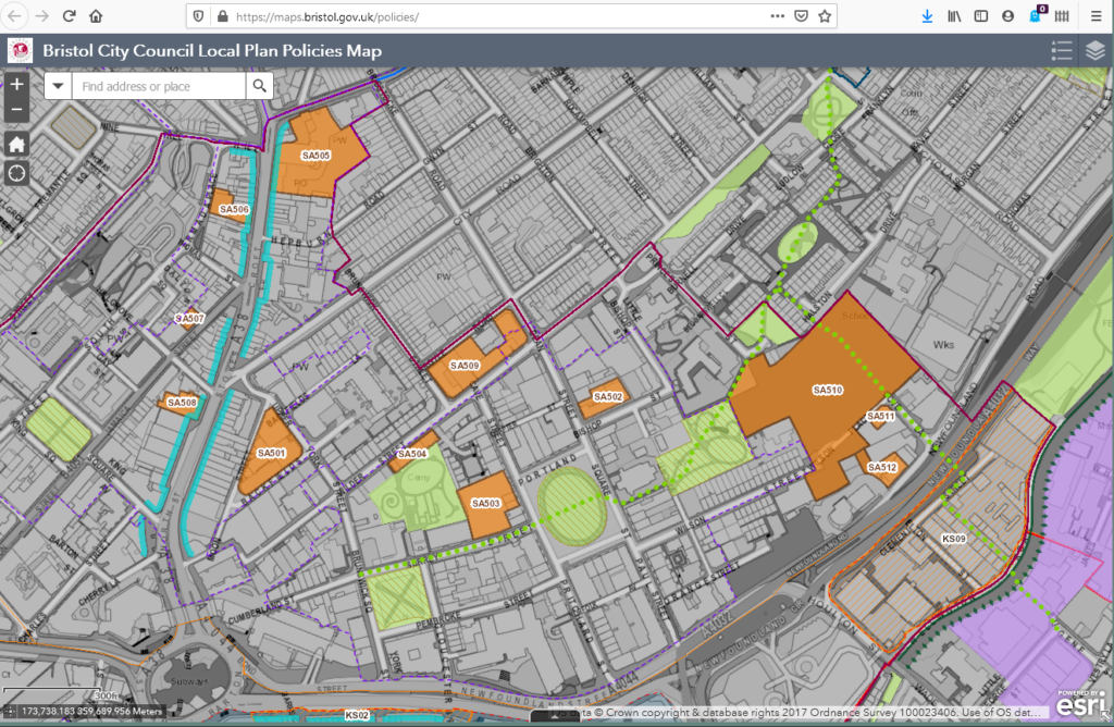
Bristol Central Area Plan Policies here
or from this page https://www.bristol.gov.uk/planning-and-building-regulations/local-plan
Sites identified in 2015 are as follows: (note some are already planning applications or approved)
- SA501 Lakota Nightclub / Former Coroner’s Court, Upper York Street / Backfields
- SA502 Land at Dean Street / Bishop Street (former Kango site)
- SA503 Land at Surrey Street / Portland Square (Sandhu’s Warehouse)
- SA504 Car Park On South East Side Of Wilder Street
- SA505 The Carriage Works & Westmoreland House
- SA506 97-101 Stokes Croft
- SA507 27-33 Jamaica Street
- SA508 35, 37, 41 Stokes Croft
- SA509 Land at Wilder Street / Argyle Road
- SA510 Land at Dove Lane / Ervine Terrace / Wilson Place / Cheapside
- SA511 F C Hammonds, 13-17 Dove Lane
- SA512 109 – 119 Newfoundland Road
- SA513 Former Macey Rewinds site, Franklyn Street
Most are noted as suitable for residential, some also for workplace/ office and some for possible addnl uses
An additional site has been identified in the recent Local Plan Review which is referenced as
- BDA 0105 rear of 64-66 Stokes Croft – used for residential or residential + workspace.
Briefing notes say:
Development should:
- Provide a contextual, heritage-led approach, taking account of the Stokes Croft Conservation Area and respecting the setting of the Grade II Listed Building at 62 Stokes Croft;
- Provide suitable access which takes account of servicing needs for properties fronting Stokes Croft;
- Be informed by a land contamination risk assessment and a Coal Mining Risk Assessment, making recommendations for remedial measures where required, as the site falls within a Coal Authority High Risk Area;
- Ensure that development would not cause harm to trees on adjacent land; and
- Respond to Draft Policy HW2 ‘Air Quality’, as the site falls within an Air Quality Management Area.
- Estimated capacity of 8-10 homes.
Portland and Brunwick Square Conservation Area Character Appraisal.
this 2008 document is used to assess proposals within the Conservation Area. read here
PLANNING GUIDANCE: this is taken into account when planning applications are considered
A masterplan for development in St Pauls was brought forward with local consultation and adopted as a Supplementary Planning Document SPD 10 in 2006
See alternatively SPD by chapters here
COGNITIVE PATHS has brought forward some proposed updates to this plan here in consultation with local organisations and helped by UWE student input.
St Paul’s Neighbourhood Plan (note this has no planning ‘weight’ but can be used to evidence community views in responding to planning applications)
Details of further projects in St Pauls and Ashley are being worked on by this year’s UWE students. these include Parks project, graffiti in Stokes Croft and Museum Portland Square
STUDENT HOUSING
Student accommodation topic paper 2014
Bristol Central Area Plan see BCAP4 Specialist Student Housing in Bristol City Centre p 13
PLANNING APPLICATIONS NOVEMBER 2020
Current planning Applications November 2nd